


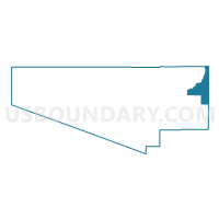
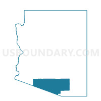
Voting District 274, Pima County, Arizona
About
Outline

Summary
| Unique Area Identifier | 525327 |
| Name | Voting District 274 |
| County | Pima County |
| State | Arizona |
| Area (square miles) | 241.78 |
| Land Area (square miles) | 241.78 |
| Water Area (square miles) | 0.00 |
| % of Land Area | 100.00 |
| % of Water Area | 0.00 |
| Latitude of the Internal Point | 32.23658210 |
| Longtitude of the Internal Point | -110.54433770 |
Maps

Graphs
Select a template below for downloading or customizing gragh for Voting District 274, Pima County, Arizona


Neighbors
Neighoring Voting District (by Name) Neighboring Voting District on the Map
- Voting District 179, Pima County, AZ
- Voting District 221, Pima County, AZ
- Voting District 243, Pima County, AZ
- Voting District 255, Pima County, AZ
- Voting District 302, Pima County, AZ
- Voting District 336, Pima County, AZ
- Voting District 374, Pima County, AZ
- Voting District 382, Pima County, AZ
- Voting District 389, Pima County, AZ
- Klondyke 12 Voting District, Graham County, AZ
- Precinct 02, Cochise County, AZ
- Precinct 29, Cochise County, AZ
- San Manuel Voting District, Pinal County, AZ
Top 10 Neighboring County Subdivision (by Population) Neighboring County Subdivision on the Map
- Tucson CCD, Pima County, AZ (853,603)
- San Manuel CCD, Pinal County, AZ (20,418)
- Benson CCD, Cochise County, AZ (12,520)
- Bonita-Klondyke CCD, Graham County, AZ (3,153)
Top 10 Neighboring Place (by Population) Neighboring Place on the Map
Top 10 Neighboring Elementary School District (by Population) Neighboring Elementary School District on the Map
Top 10 Neighboring Unified School District (by Population) Neighboring Unified School District on the Map
- Tucson Unified District, AZ (472,675)
- School District Not Defined, AZ (69,809)
- Vail Unified District, AZ (52,532)
- Tanque Verde Unified District, AZ (11,481)
- Benson Unified School District, AZ (8,210)
- Mammoth-San Manuel Unified District, AZ (5,460)
Top 10 Neighboring State Legislative District Lower Chamber (by Population) Neighboring State Legislative District Lower Chamber on the Map
- State House District 23, AZ (370,479)
- State House District 30, AZ (231,236)
- State House District 25, AZ (208,220)
- State House District 5, AZ (192,258)
Top 10 Neighboring State Legislative District Upper Chamber (by Population) Neighboring State Legislative District Upper Chamber on the Map
- State Senate District 23, AZ (370,479)
- State Senate District 30, AZ (231,236)
- State Senate District 25, AZ (208,220)
- State Senate District 5, AZ (192,258)
Top 10 Neighboring 111th Congressional District (by Population) Neighboring 111th Congressional District on the Map
Top 10 Neighboring Census Tract (by Population) Neighboring Census Tract on the Map
- Census Tract 40.64, Pima County, AZ (7,696)
- Census Tract 40.26, Pima County, AZ (5,586)
- Census Tract 40.51, Pima County, AZ (5,089)
- Census Tract 40.61, Pima County, AZ (4,821)
- Census Tract 40.44, Pima County, AZ (3,950)
- Census Tract 3.03, Cochise County, AZ (3,457)
- Census Tract 9616, Graham County, AZ (3,161)
- Census Tract 4705, Pima County, AZ (3,152)
- Census Tract 24, Pinal County, AZ (1,997)
- Census Tract 40.52, Pima County, AZ (1,944)
Top 10 Neighboring 5-Digit ZIP Code Tabulation Area (by Population) Neighboring 5-Digit ZIP Code Tabulation Area on the Map
- 85730, AZ (38,323)
- 85747, AZ (23,058)
- 85641, AZ (21,753)
- 85749, AZ (19,032)
- 85748, AZ (18,087)
- 85643, AZ (9,810)
- 85602, AZ (9,464)
- 85631, AZ (3,630)
- 85619, AZ (50)